Showing posts with label Background. Show all posts

Friday, November 30, 2012

Southbound Express


Next stop, Antarctica! I’m starting the trek down to the McMurdo Dry Valleys today. If everything goes well, I should be arriving in Christchurch, New Zealand on December 2 (everyone should enjoy December 1st for me—I’m going to lose it entirely when I cross the international date line!), and will head to McMurdo Station on December 4.


We're heading here. Soon. Image courtesy NASA Goddard.

The Cold Dirt field team has doubled in size again, which means I’ve got an outstanding roster of scientists and students (and even an artist) converging on the Antarctic Dry Valleys from all over the country. We’re focused on two big projects this year: 1) sampling the buried ice sheet that was trapped in Garwood Valley during the last ice age so we can determine where the ice came from, and 2) exploring the hidden groundwater system that sustains life in Taylor Valley soils. Whenever internet access is available, I’ll keep photos, videos, and reports from team members up-to-date so you can follow the adventure online.

The first half of the team will meet in Los Angeles this afternoon to fly to New Zealand. The advance team members include:

Kelly Hughes, a graduate student at Portland StateUniversity. Kelly works with Andrew Fountain (who will be joining us later in the season) and is working on a thesis related to ice, groundwater, and geochemistry.

Jay Dickson, a veteran of many Antarctic field seasons (including last year’s season in Garwood Valley--and seriously, follow that link, I love the headline). Jay is a researcher at Brown University and is leading the time-lapse camera experiment that is recording dramatic erosion in Garwood (more about that later!).

Lily Simonson, the expedition artist. Lily is a painter whose recent projects have included renderings and interpretations of sea life collected during research cruises (also sponsored by the NSF). Lily is at the forefront of sharing the complexity and beauty of the natural world through art. You can see some of her ocean creature work here.  

It’s just about time to catch the first flight. Stay tuned, though—we’ve got a live video chat from Antarctica scheduled for a week from today with students at Christa McAuliffe middle school in Florida. Keep those questions and comments coming!


Thursday, January 5, 2012

New season, new links

I'm back in McMurdo, and a 2011-2012 season set of posts is soon going to be on its way. In the interim, for anyone who didn't see it, here's a link to the CBS Sunday Morning coverage of Antarctica, and the LTER's work there: "Destination Antarctica."

For those looking for something new, here's a view of the McMurdo Station live webcam.

Saturday, June 18, 2011

It's Official! Back to Garwood Valley

Exciting news! I've just received word that the National Science Foundation has approved my proposal to continue work in Garwood Valley!

We've been authorized to spend three years and three field seasons exploring the buried ice that we reconnoitered this past winter, in order to learn about the climate during the transition out of the last ice age. The official NSF site about the award can be found here.

Some folks might wonder how it is that scientists fund the research that they do (in Antarctica and elsewhere). Many scientists are supported part of the year by the university at which they work (the scientist's salary is paid for teaching classes, advising students, serving on university committees, etc). For the rest of the year, and if they want to do research with expensive equipment or in far away places, require that the scientists secure grants from state, local, and federal government agencies, or from private companies or foundations.

Most federal agencies (like the US National Science Foundation) get an annual budget from the US Congress. Some of that budget is dedicated to research programs (for example, the Antarctic Earth Sciences research program, which funds my work). Scientists send research proposals to the funding agencies ("Hey, look at me! I've got a great hypothesis that needs testing!"). Usually the scientists work in teams to tackle bigger problems than an individual could solve on his or her own.

The program manager at the funding agency then assembles a team of scientists to evaluate the proposals. This process is called peer review. The review panel reads through the proposals to determine where the strengths and weaknesses are for each proposal. This process is very helpful--not all the proposals will be funded every year,but  every proposal gets feedback. When else does a scientist have a room full of experts providing feedback on their best ideas?

The review panel doesn't just pick favorites, of course! Every proposal is evaluated based on criteria that are established by the funding agency. The NSF, for example, evaluates proposals based on the intellectual merit of the proposal ("Is this good science, that solves an important technical problem, or that tests a major hypothesis?") as well as the broader impacts of the proposal ("What societal good will come from this work? Will students be trained? Will the general public learn about the research through an outreach program?").

Once the proposals have been evaluated by scientists, the program manager (usually a scientist, too!) makes a set of recommendations to the funding agency, and then the administrator of the funding agency approves or rejects the proposals. The proposals all have a budget attached to them ("How much will it cost to answer this question?"), which is then paid for with a grant from the funding agency.

I count myself very lucky to have a chance to go back to Garwood Valley to do science as the head of an NSF funded project. Only about one in four proposals are funded on average, and that ratio has been falling in recent years. It's very unusual for a new researcher like me to be named the principle investigator of a big project like this. It's all exceptionally exciting!

Stay tuned for updates as I assemble the field team and prepare to return to Antarctica!

Thursday, November 4, 2010

Back in Town

I'm back at McMurdo Station this weekend to process the samples I've been collecting over the past three weeks!


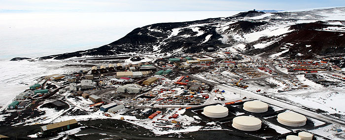
McMurdo Station is the main US base in Antarctica and is home (as of yesterday) to 1143 scientists and support staff (I guess I make it 1144 in total). The base is perched on the rocky shores of Ross Island, about a 45 minute helicopter flight from Lake Hoare in Taylor Valley.

In the above photo, you can see the big fuel tanks (to the right) that keep the lights on and the buildings warm. In the middle of the picture is the cargo yard, where several years of supplies are kept (in case weather turns bad, planes can't fly, and the resupply ship can't break through the ice). Over on the left side of the image is a gray building that's in three pieces connected by ramps. That's the Crary laboratory, which is the scientific heart of the station. It's where I'm writing from right now!

The bright white expanse to the far left is the frozen surface of the Ross Sea. All in all, it's a very tidy station, but after a few weeks out hiking and sampling, it seems like the big city!

In my next post, we'll take a closer look at what I'm doing in the lab, and just what it means to be washing dirt.

Monday, October 11, 2010

This Orange Earth (or, Why It's So Cold)

Southbound. Bags are packed, parkas and boots are on, and I'm loaded aboard a US Air National Guard C17 cargo plane with 38 friends, colleagues, and support staff, winging our way wouth towards Antarctica.

This blog is called "Cold Dirt," and as you'll see, it's all about the cold, frozen, icy, and in places, rapidly thawing soils found in the McMurdo Dry Valleys of Antarctica. Before I dive in to the science of permafrost geology, and glaciology, and all the other research subjects that are the focus of this expedition, I thought it might be worthwhile to unpack these two ideas--"cold" and "Dirt."

Everyone likes to complain about the cold (even Antarctic explorers!), but most folks don't stop to think about why the Earth's poles are as cold as they are. We've become used to seeing pictures from space, or even just plotted on a globe, showing ice caps at the north and south ends of our planet. Why is that?

Almost all of the heat that we feel at the Earth's surface comes from the sun (a little bit trickles up from the warm interior of the Earth, but not enough to feel in most places). The sun beams light towards the Earth, which travels though space, and ultimately arrives at the top of our atmosphere. If you put a solar panel right at the top of the atmosphere to collect that energy, you'd find that every sqaure meter (imagine a solar panel one meter, or about 3 feet, on a side) would pick up about 1250 Joules of energy every second. A Joule is a fiddly unit of energy (your electric bill doesn't count Joules, and for good reason), so it helps to think in Watts (a Watt is one Joule of energy being collected or used every second). A Watt is a measure of power (so a 300 Watt hair drier is more powerful than a 400 Watt hair drier, because every second that it's on, it can turn 100 more Joules of electrical energy into heat for your hair than the 300 Watt drier). Back to the top of the atmosphere, some of that sunlight (solar energy) gets reflected back into space (goobye sunshine!) and some of it shines right down through the atmosphere to the surface. Once it finally reaches the ground, some of that sunlight gets absorbed, warming up the land, ocean, trees, people--everything at the Earth's surface (this is why sunlight feels warm on your skin--you're absorbing energy in the form of solar radiation, and converting it into energy in the form of heat).

That's how the Earth gets warmed: solar energy, in the form of radiation gets absorbed and turned into heat. But why are the poles cold? To understand this, it might  make sense to come down from the top of the atmosphere, and to head into the kitchen or to a  grocery store. Find yourself a nice round orange with a label sticker on it (they usually say, "Florida," or "Sunkist," or even "Apple" if you've got a sarcastic grocer). The orange represents the Earth. The stem-spot on the orange represents the South Pole. For the sake of simplicity, now pick up the orange and hold it out at arm's length, with the south pole pointed down at the floor (if there'a fruitfly buzzing around the orange, somewhere near it's lower half, that represents me, sitting here on this plane). By holding the orange out at arm's length, now you represent the Sun. If you spun around in a circle by pivoting on your toes, you'd be simulating the Earth revolving around the Sun. You'd also look kind of silly.

Now, about that label sticker. On your Orange Earth, the sticker represents a blanket, spread out for a picnic (yes, people picnic in Antarctica, but that's for another post). Hold the orange with your thumb on the south pole, and another finger on the north pole (the opposite side of the orange). Now peel off the sticker, and put it on the side of the orange, right in a spot that's half way around the orange between the north orange pole and the south orange pole. Now the sticker is on the orange's equator. Hold the orange back at arm's length, with the south pole pointed at the floor, and take a look at the sticker. If the sticker is pointed right at you (remember, you're the sun), you can see the whole sticker. All the energy coming out of you (the sun) can be absorbed by that big picnic blanket, rapidly warming it up under the noon sun (if you've every picniced near the equator, you know it can get pretty hot, pretty fast in the direct sunlight). Now peel off the sticker, and put it down near the stem of the orange (the south pole). Now the picnic blanket is in Antarctica. If you hold the orange back out at arm's length, with the south pole (stem) pointed at the floor, what do you see? You can't see the whole face of the sticker! The curvature of the Earth points the sticker away from your eyes (the sun), so that you can only see a little bit of it. Now, the picnic blanket can only absorb sunlight from you, then sun, if the sun's rays (solar radition) can travel from then sun to the ground. Since you can only see a small portion of the sticker, it means that only a small portion of the sticker gets direct sunlight, that can be absorbed, causing the blanket to warm up. The picnic blanket (sticker) near the pole gets less direct sunlight, over a smaller surface area (the part of the sticker you can see), than the picnic blanket at the equaotr. It's going to be a cold lunch in Antarcitca!

The fact that the poles absorb less solar radiation than the equator is only part of the reason that the poles are so cold. The other piece of the puzzle comes from how the two picnic blankets lose heat. Just about everything in the universe loses heat by emiting infrared radiation. Infrared radiation is the kind of radiation that you feel when you stand in front of a fireplace or radiator (makes sense why they call it that). The ground loses heat at night by radiating infrared energy off into space (this is on reason why clear winter nights are so cold). Both picnic blankets lose heat at about the same rate, radiating infrared radiation from their surfaces back out into space. The blankets have a "heat budget" and get hotter when they absorb more solar radiation that they lose through infrared radiation, and getting cooler when they lose more heat than they absorb (the same way a bank account--a personal budget--grows bigger when you spend less money than you earn, and gets smaller when you earn less money than you spend). The polar picnic blanket takes in very little heat from the sun, but loses plenty to space, while the equatorial picnic blanket gets plenty of sunlight, and only loses about as much energy as the polar blanket, helping keep it heat-rich and warm.

The last wrinkle to why the poles are so cold can be figured out by holding your orange Earth out at arm's length and taking a picture of the orange with a camera that has a flash. What do you notice when you look at the picture of the orange? Most of the orange looks about the same in the picture, but the sticker on the orange should look super-bright in the light from the flash. The reason the sticker looks so much brighter than the rest of the orange is because the sticker reflects more of the light from the flash than the orange does (this is becuase the sticker is shiny and light-colored). The fraction of the light that a surface reflects is called its "albedo" (something like concrete that reflects half of the light that gets shined on it has an albedo of 1/2, while something that reflects all the light that's shined on it, like a perfect mirror, has an albedo of 1). Fresh snow has a very high albedo (more than 9/10, or almost 1). Reflected sunlight never gets absorbed by the ground, meaning it never gets to be part of the ground's energy budget, and can't warm it up. All of the snow and ice at the Earth's poles means that they have a high albedo. The poles reflect a lot of their tiny share of sunlight back into space, so that it never gets a chance to help warm the ground.  

So that's the "cold" part of "Cold Dirt." I'll talk more about the "Dirt" once I reach my science site. For now, though, I've got a few more hours of flying time, before we land on the ice runway at McMurdo Station (edit: made it in on the second pass! Hello from McMurdo!). Time for a quick nap in the parka, and dreams of fresh oranges.

Thursday, October 7, 2010

Getting there (from here)

If you're not a penguin (they swim), airplane is the best way to reach Antarctica. Antarctica is the southern continent, so from anywhere in the USA, you could just go south, and you would eventually reach the Antarctic. But Antarctica is a big place, so just "getting there" doesn't necessarily mean that you've gotten where you need to go.

I'm working in the McMurdo Dry Valleys (77S 162E). If you pull out a globe (okay, or Google Earth--it has some great satellite images) you'll seem that this is nearly due south of New Zealand. If I flew south from Providence, RI, my old home, I'd arrive on the wrong "side" of Antarctica (technically, the wrong coast). The Antarctic Penninsula is fascinating in its own right, but with a land area about the size of the US and Mexico put together, there'd be a lot of Antarctica between me and the Dry Valleys.

So I'm off to Aukland, New Zealand tonight. From there, it's on to Christchurch on the south island. More from NZ (and from "tomorrow"-- I'm about to gain 16 hours of time zone!)

Tuesday, October 5, 2010

Into the Blizzard (Again)

I'm too far down valley and that snow is closing in fast. At my feet are rocks, boulders, and sand--shattered bowling balls and ball-bearings of brown and red dolerite. I'm digging a soil pit, and when the hole is knee-deep, I hit pay-dirt. Ice, actually. Three million year old glacier ice, some of the oldest ice on Earth, that's been moving as a debris-covered glacier, inching its way down valley (the absolute oldest ice is even further down the valley). I've had my eyes on the ground all afternoon, and now the clouds that were skirting the mouth Beacon Valley have marched their way up towards me. The air is filled with with swirling snow, glinting in the failing sun like harsh confetti. The temperature is dropping fast as the warm rays of the sun are swallowed up by the growing storm. I've got thirty pounds of sand and ice in my pack, and three kilometers to make it back to camp before the weather turns to whiteout. It's going to be an interesting hike...

That was December of 2004. It was my first season in the Antarctic as a scientist studying permafrost (frozen ground) as part of a project to understand frozen landscapes on Mars (the "season" is summer in the Antarctic--winter back home in the US--when field work mostly occurs in Antarctica). Now it's 2010 and I'm about to embark on my fifth field season as a permafrost geologist working with the McMurdo Dry Valleys Long Term Ecological Research Project. As part of the National Science Foundation's Antarctic Organisms and Ecosystems program, I'm trying to figure out how the frozen ground in Taylor Valley feeds water and nutrients to the southernmost functioning ecosystem on Earth, and how this microbial and invertebrate "canary in the coal mine" is going to respond to changing climate conditions.

Keep with this blog to find out more about the science going on in this cold, dry place. I'll be updating from a field camp with limited web access, so feel free to ask questions, think critically, and share in the adventure of polar exploration!