Monday, December 10, 2012

How to Pack for Antarctica

If the weather holds, we should be on our way to Garwood Valley tomorrow! Of course, before any big trip, you've got to pack the car. Or, in this case, pack the helicopter (a Bell 212, for those aviation nuts out there).

So, what goes into a ~2-3 week camping trip to the Dry Valleys? We've got tents for living and working in, stoves to cook food and keep warm, sleeping bags, tools, a generator to run our computers and to charge our radios, a satellite phone for safety, and lots of food (243 pounds of dried/canned food and 97 pounds of frozen food). What's on the menu? Stir-fry, curry, chili, steak night (halibut and beef),  and "Thanksgiving" for dinners; PB&J for lunch (along with beef jerky and trail mix), and lots of oatmeal, coffee, and cocoa for breakfast. It all adds up to almost 2,000 pounds of gear.


Pack your bags! From left to right: Kelly, Lily, Jay, Joe.

Here's a sampling of the manifest:

Backpack, Mens
3
Backpack, Womens
1
Barrel, 55 gallon,  for greywater and/or urine
1
Battery, AA
8
Battery, AAA
8
Broom, Whisk
2
Bungee Cord
4
Burlap Bag
10
Cargo Strap
2
Cargo/Duffle Bag
6
Chair, Camp, canvas type
4
Coffee Grinder
1
Coffee Maker, Espresso, stove top
1
Crowbar, 12"
1
Cutting Board, Sm, 8"x8", for kitchen box
1
Dustpan
1
Ensolite Pad, 1/2"x28"x84"
4
Extension Cord, 50 ft
2
Fire Blanket
1
Fire Extinguisher, 2.5 LB
2
First aid kit, Individual/Personal
4
First aid kit, Mountain Medic
1
Food Cooler, 10-15 gal.
3
Funnel, Female, Urinary
1
Funnel, Screw-in type for 55 gal. Drum - greyh20/pee
grey water and general use
1
Garbage Bag, 32gal., clear, 125/bx
1
GPS, Garmin, 76
2
Grater, cheese
1
Hammer, Geologist, Rock
1
Hammer, Sledge, 2-3 LB
2
Hammer, Sledge, 6-10 LB w/ long handle
1
Hand warmer
10
Helmet
2
Human waste bucket, 5gallon w/ gamma lid
3
Jerry can of MOGAS, 5 gal
2
Jerry can of PREMIX, 5 gal
1
Kitchen Box Supplement, one extra person
2
Kitchen Box, 4-Person
1
Ladder, 6'
1
Matches, Strike-On-Box, 250/bx
2
Mirror, for kitchen box
1
MOUNTAIN DOME TENT
4
Paper Towel, per package
10
Paracord, aka P-cord, standard
100
Pick, Rock
2
Pile Liner
4
Pillow, Camp
4
Pot, 24 QT, Stockpot
1
Power Strip
2
Propane, 40 LB tank
2
Purrell, waterless soap
4
Rock Bag, Large ~ 14"x18"
100
Rock Bag, Medium ~ 10"x17"
100
Rock Bag, Small ~ 6"x11"
50
Rock Box
10
Seat, Toilet, Screws into Human Waste Bucket
1
Shovel, Short Round
2
Signal Mirror
1
SIPRE Kit
1
SLEEPING BAG, UNDER 6' TALL
4
Spout, Flex
1
Stove, Coleman, Propane w/ regulator (NEEDS HOSE)
2
Survey Tape, Fiberglass, 100M / 300'
2
Survival Bag, Local, 2 person
2
Table, Allulite - short fat - 29"x48"
1
Tape, Duct
6
Tape, Electrical
2
Tarp, Nylon, large, approx. 8'x12'
2
Tent, Endurance, 8'x21'
1
Thermarest
4
Thermos, 1 QT Nissan (includes camo)
4
Toilet Paper, per roll
8
Tool Kit  (standard)
1
Trowel, Garden (soil sampling)
2
Urine bottle, 32 oz.
8
Urine container, 5 gal
1
Water Bottle Warmer
4
Water Bottle, 1 QT, Nalgene
4
Water Cooler, 5 gal
1
Water Filter, Katadyn System
1
Wet Wipes, tubs
4
Wrench Set, Combo, Metric
1
Wrench Set, Combo, Standard
1


As you can imagine, it's quite a bit different than Robert Falcon Scott's packing list when he led the Terra Nova expedition to the pole. You can see his packing list here. We're bringing fewer Siberian ponies. Actually, no ponies of any kind.

Saturday, December 8, 2012

Where's Antarctica?!

It's Sunday morning, here at McMurdo--a day for sleeping in a little, checking and re-checking gear, and maybe going for a stroll around Ob' Hill before station wakes up for a mid-day brunch. 

Imagine my surprise, when I awoke this morning and headed towards the Crary Laboratory: McMurdo Sound is socked in with thick fog.


Dude, where's my continent?

Normally, I should be able to look out my lab window and see the Dry Valleys and the Royal Society Range soaring up from above the Ross Sea. This morning, it's just thick, billowy white out there. Part of the Crary Laboratory building is in the foreground.  

My guess is that the warm weather we've been having here at McMurdo (high temperature today: +4˚C or 39˚F) has led really humid air developing during the day (lots of snow and ice to melt). When temperatures drop at "night" (when the sun is low in the sky--but still above the horizon) to temperatures below freezing, all this moisture condenses out and forms the thick fog banks that can cut McMurdo off from the rest of the Ross Sea region. 

It's lovely, if a little mysterious, on a Sunday morning. But fog like this on a working day means no helo flights and no planes coming or going from Christchurch. I hope it clears up before Wednesday: we're hoping to fly across the sound on 12/12/12, and don't want to land at Camp Brigadoon.

UPDATE: 13:30


That's better. Mount Discovery is back, peeking out above the fog, along with the Kukri Hills (the low hills to the right).

Thursday, December 6, 2012

Sweet home McMurdo -- And Happy Campers

The weather in Christchurch, New Zealand, has been beautiful all week. The problem is, it's been snowing in McMurdo, which means our plane could not safely land. New Zealand is a nice place to be stranded, but after three days of waiting for the weather to clear, the advance team was ready to go.

And here we are! After a loud, bumpy, long flight south in an old-fashioned C130 cargo plane, we arrived last night. 

Here's what the scene looks like at McMurdo. (The McMurdo webcam is also a pretty good way to check out the weather on station--we kept a close eye on the camera from New Zealand to see when the weather would clear. 

Right now we need to prepare to get into the field and to make up for those lost days in New Zealand. Our new Antarcticans (Lily and Kelly) are off at Happy Camper school, the nickname we give to Antarctic Survival training. 


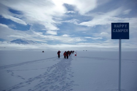
Happy Campers walk down a flag-line trail on the Ross Ice Shelf. Photo courtesy Ludovic Bruker.

Antarctica can be a dangerous place, so snow school teaches new Antarcticans how to prepare themselves for extreme cold weather. The two-day course is taught mostly outside. 


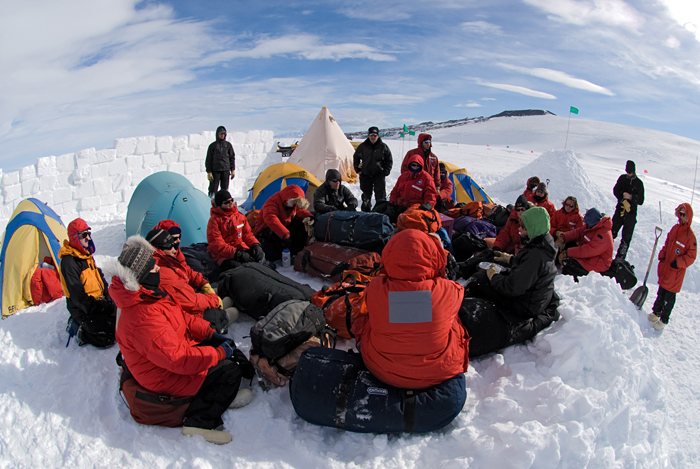
Happy Campers take shelter behind a wall made out of snow blocks (quarry your own!) and listen to a field safety instructor. A yellow, pyramid-shaped Scott Tent is in the background, next to a pyramid-shaped snow cave. Cozy. Image courtesy Chris Linder, WHOI.

Campers learn how to make the most of their extreme cold weather clothes; how to assemble the various tents they might be living in; how to prepare emergency snow shelters; and how to use the radios that are the main way we communicate with McMurdo station when we're in the field. 


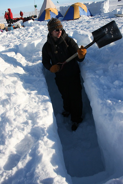
It isn't much, but a snow trench makes for a good spot to sleep out of the wind in the event of emergency. Photo courtesy Eli Duke. 

Campers also learn how to use emergency stoves to cook survival rations (yummy), and how to diagnose and treat cold injuries like frostbite. Most of the time, people who get frostbite don't even notice it, which is why it's important for our team to keep an eye on each other (particularly, each others' noses, which can freeze in a strong wind). 

The most memorable moment for many people is during the whiteout drill. When the snow blows in to McMurdo (like it did the last few days, keeping us from flying in), a whiteout can make it impossible to see more than a few inches in front of your face. The bucket-head drill simulates a whiteout. Campers have to search for a friend who's gone missing in the snow. 


Can you see him? I can't even see my luxurious moustache! Image from Kenneth Sims, UWY

Meanwhile, Jay and I (safely without buckets on our heads) are packing up camp gear and getting logistics ready for our move to the field. More about what you pack for lunch (and breakfast and dinner) in Antarctica in an upcoming post. 


Friday, November 30, 2012

Southbound Express


Next stop, Antarctica! I’m starting the trek down to the McMurdo Dry Valleys today. If everything goes well, I should be arriving in Christchurch, New Zealand on December 2 (everyone should enjoy December 1st for me—I’m going to lose it entirely when I cross the international date line!), and will head to McMurdo Station on December 4.


We're heading here. Soon. Image courtesy NASA Goddard.

The Cold Dirt field team has doubled in size again, which means I’ve got an outstanding roster of scientists and students (and even an artist) converging on the Antarctic Dry Valleys from all over the country. We’re focused on two big projects this year: 1) sampling the buried ice sheet that was trapped in Garwood Valley during the last ice age so we can determine where the ice came from, and 2) exploring the hidden groundwater system that sustains life in Taylor Valley soils. Whenever internet access is available, I’ll keep photos, videos, and reports from team members up-to-date so you can follow the adventure online.

The first half of the team will meet in Los Angeles this afternoon to fly to New Zealand. The advance team members include:

Kelly Hughes, a graduate student at Portland StateUniversity. Kelly works with Andrew Fountain (who will be joining us later in the season) and is working on a thesis related to ice, groundwater, and geochemistry.

Jay Dickson, a veteran of many Antarctic field seasons (including last year’s season in Garwood Valley--and seriously, follow that link, I love the headline). Jay is a researcher at Brown University and is leading the time-lapse camera experiment that is recording dramatic erosion in Garwood (more about that later!).

Lily Simonson, the expedition artist. Lily is a painter whose recent projects have included renderings and interpretations of sea life collected during research cruises (also sponsored by the NSF). Lily is at the forefront of sharing the complexity and beauty of the natural world through art. You can see some of her ocean creature work here.  

It’s just about time to catch the first flight. Stay tuned, though—we’ve got a live video chat from Antarctica scheduled for a week from today with students at Christa McAuliffe middle school in Florida. Keep those questions and comments coming!


Tuesday, July 3, 2012

Antarctic Soil: It's a Sign of Science

Two stories about Antarctic water tracks and wet patches have been featured on Hear the Answer--a feature of PBS, NSF, and Finger Lakes Productions International.

You can hear them at:

What type of soil will suck water right out of the air?

and

Why do martian researchers study Antarctica?

Not a bad 90-second summary of these two neat finds.

Tuesday, January 17, 2012

(Almost) Live and (somewhat) life-like from Garwood Valley!

After eight great days in the Garwood, the team and I have moved to Taylor Valley (where I was based last year) for a change of pace, some new soils and rocks to samples, and of course, to get access to the internet, so I can upload images to this blog. We had a tremendous week of fieldwork, and are looking forward to looping back through at the end of the month to finish this year's research.

Here's a few 3D images of what we've been up to. You'll need red-blue 3D glasses to see the view in stereo, but without them, you'll get some idea of the scenery. 


Here's a view of almost every part of the valley we've been working on. Up front close is the buried glacier (called the "ice-cored drift") that fills Garwood Valley. Beyond it is the floodplain of the Garwood River, which cuts through the ice-age deltas we've studied to learn more about when the valley filled with ice. Behind the three deltas is more "ice cored drift," and beyond that, the modern Garwood Glacier. 


Here's home-sweet-home in the Garwood, our camp. We're on the Garwood River plain, in front of the buried ice (that helps keep the wind down). The big tent near the camera is an 8 by 21 foot "Endurance" tent, where we cook, eat, and repair our science gear (it's also our lab, in a pinch). The big antenna next to it is an HF radio for calling back to McMurdo. Behind the Endurance are our bedrooms--each team member gets his own little tent to sleep in. The sand is the valley is pretty soft, making for a cozy night's sleep in a sleeping bag.


This shot shows two team members, Dr. Andrew Fountain (on the right) and James "Jerome" Bethune on the left. James just finished college and is here working with Andrew and I as a field hand, and on some research projects related to how different geological surfaces become better or worse homes for algae. They're standing next to the track of a seal (to the left) that crawled its way inland from the sea (nobody knows for sure why they do this some times). The "ice cored drift" is behind them, and beyond that, the Ross Sea (covered in ice) and the Brown Peninsula.


Here's Berry Lyons and his student Julie sampling a "thermokarst pond" in the buried ice. When the ice melts, it can leave behind a hole that fills up with the meltwater. There's ice exposed behind them, that's feeding the pond. We're trying to learn how these ponds form, and why different kinds of algae chose to live in one pond and not another (some of the algae has wild colors--tye-dye reds, greens, and yellows).


This picture shows Dr. Rickard Pettersson and Jerome working with the ground-penetrating radar. Rickard is carrying a very precise GPS so we know exactly where he's scanned. The radar bounces radio waves off the different layers in the ground (soil on top, buried ice, the bedrock below) so we can measure how much ice is in the valley, and how many different layers are in the deltas. It's a heavy pack to haul all over the Garwood, but Rickard (who's joined the team from Sweden) doesn't mind working hard, or thinking through hard scientific problems. 

The only team members I haven't shown you are Jay Dickson (who is making some amazing time-lapse movies of the "ice cliff" melting) and Thomas Nylen (who is managing the weather station in front of the buried ice). I'll post pictures of them in action, and some of the data they've gathered in the next post.


After working hard all week, the only task remaining was to load up our gear into a big cargo net and to wait for a helicopter to fly us and our camp equipment to Lake Hoare. The Bell 212 is an extremely powerful helicopter that makes a lot of wind as it lifts 1900 pounds of tents, fuel, rock samples, and duffel-bags. It's important to watch the helicopter take off to make sure that the cargo net stays safely packed and away from any obstacles (like the wall of ice next to our camp). The Garwood is a very sandy valley, and, as the winds roared while the helicopter took off, I managed to collect one last sediment sample in my beard. Nothing quite like playing in the dirt. 

Saturday, January 7, 2012

Garwood-bound/McMurdo-bound

It’s funny how one word can mean two exactly opposite things. I’m at McMurdo Station, waiting to kick off this year’s research program in Garwood Valley (one of the southern McMurdo Dry Valleys). My team and I arrived last Monday, and have spent the week assembling our camp gear, testing scientific instruments, and packing up food and supplies. We hit the ground running, with the goal of being Garwood-bound on Friday, January 6th. But, weather (it’s been snowing quite a bit lately), coupled with a tight helicopter usage schedule, and mechanical problems with one of the big Bell 212 helos that we need to move our camp in, have kept us McMurdo-bound this weekend. The good news is, if the snow clears, we’re on the schedule for Monday, and can get rolling with our science! (The other good news is that the McMurdo galley has the best brunch below 65*S, so it’s a treat to be able to have a few more days of delicious chow before the menu changes to camp cuisine).


 This is the view out my lab window at McMurdo. That bright white space in the background is the direction I need to be flying, and those little flakes in the foreground are getting in the way!

What’s this season all about?

During the last glacial maximum (the LGM, which was the peak of the last ice age), about 20,000 years ago, Antarctica was a colder place than it is today. The ice sheets that cover the continent grew in the cold, and like giant glaciers, came pouring out of the high interior mountains of Antarctica and flowed down towards the coast. During the LGM, so much ice came flowing out of west Antarctica that it literally filled up the Ross Sea. The flood of ice spilled up into the valleys that surround the Ross Sea—so much ice was draining into the region that the glaciers flowed up hill!

But then the planet began to warm up again. The ice age was waning. The “grounding line,” which is the point where this wall of ice met the ocean, began to move back inland. Ice drained from some of the flooded valleys (but not all—Garwood being one that kept its ice). This is where Garwood Valley becomes important. Warming climate conditions stopped this flood of ice in its tracks, melting back ice that been streaming out of the West Antarctic ice sheet. Today, scientists are concerned that the West Antarctic ice sheet is experiencing so much warming that it may melt back catastrophically. When the ice melts, the water pours into the ocean, raising sea level.

This is a map from Conway et al. (1999) showing where the "grounding line" for the West Antarctic ice sheet is thought to have been over the last few thousand years. Garwood Valley is the green dot.

One of the big goals of this project is to help understand when, and under what temperature conditions, did the West Antarctic ice sheet flood into the Ross Sea region, and when, and under what temperature conditions did it get melted out. By Understanding the West Antarctic ice sheet’s response  to past warming, we can inform predictions about how it will respond to future warming.  

So, what’s a geologist doing all caught up in a story about glaciers and ice? As it turns out, Garwood Valley is a sticking point for the West Antarctic ice sheet as it came flooding out to sea. (Garwood is the green dot on that map). When the ice flooded into Garwood Valley, it dammed a tiny river that is fed by a glacier in the valley (the Garwood River). Like sticking a plug in a bathtub drain, the ice dam held back the water, causing a lake to rise in the valley. Eventually, a large delta grew in the lake where the river entered it, dropping off sediment every year during the summer melting season.


This is a satellite image of Garwood Valley. To the right is the modern Ross Ice Sheet (the sea). The tongue-shaped thing left of that is buried West Antarctic ice sheet ice. To the far left is the modern Garwood Glacier. Snaking its way down to the sea is the modern Garwood River.

This lake is one of the keys to figuring out when the ice flooded in, when the ice melted out, and what the temperatures in the Dry Valleys were like when all this happened. As the lake grew, algae living in the delta were buried, along with the shells of microscopic organisms that produce calcium carbonate shells. The age of these plant remains (algae and carbonates) can be determined by carbon dating, and by uranium-thorium dating. Since the lake deposits are actually sitting on top of the ice plug (more about that in another post), the lake deposits have to be younger than the ice flood, giving a minimum age for when the valley filled with ice.

 Right in the middle of this zoom you can see the deltas. The river bends around them. Looks pretty wet, doesn't it?  Thanks to Paul Morin and PGC for the great satellite images!

What happened to the lake? We can tell that the lake drained by cutting through the ice plug because the deltas get lower and lower as they get younger and younger. In order for the lake to drain, there has to be somewhere for the water to drain to. If the grounding line hadn’t moved past Garwood valley, the lakes could not have drained into the open ocean. So by dating when the lakes drained, we can learn when the ice had melted back past Garwood Valley.
 
Best of all, because the chemistry of the lake sediments can be used to figure out what temperature the water was, we can figure out what the climate was like when the ice filled the valley and when it left. I really like it when rocks can tell us something interesting about ice!

And, of course, if you don’t entirely believe the history I just told you, here’s one last bit of evidence. The ice that flooded the valley during the LGM is still there. It’s buried by delta sediments, and is rapidly melting away where it’s been cut into by the modern Garwood river. We’re trying to figure out just how fast this old ice is melting, so we can know how much longer it will be around, and what will happen to buried ice like it elsewhere in the Dry Valleys when temperatures start to rise.

This is the famous Garwood Valley "Ice Cliff." That's buried ice that got its start deep in West Antarctica, topped by layers of river-deposited sediment. I'm there in green, next to Andrew Fountain (from Portland State University), and Thomas Nylen (in blue). Thanks to Jim O’Connor of the USGS for the awesome photo, and for extensive amounts of insight in piecing together the geological history of the valley.