Thanksgiving at the Lake Hoare Camp is a major event!
People from all over Taylor Valley hiked in to camp on Thursday to share Thanksgiving dinner with us, swelling our numbers from 6 to 30! We definitely needed the help to polish off the feast: a 28 lb. turkey, sweet potato casserole, stuffing, cornbread pudding, cranberry sauce and homemade chutney, gravy, pumpkin rolls, green peas, and 8 homemade pies.
I should add, we don't eat this well every day.
We've all heard of going "over the river and through the woods," but my heart goes out to the members of the snow patch project, who hiked over the Canada glacier to get here for dinner--and then hiked back the same night! (While the rest of us napped and digested).
It's not all feasting these days, though. I've been hard at work with Andrew Fountain, the chief of the project I'm working on, collecting soil samples in wet and dry portions of the permafrost. We're keeping these samples frozen once they're collected, so that colleagues of ours in Virginia can count the number of nematodes and microbes in the soil to see how the biological community responds to the underground streams I've been working on.
Friday, November 26, 2010
Tuesday, November 23, 2010
Well Met
Despite strong, gusty winds, we had a good day out at the weather stations (sometimes called "met" stations--short for "meteorology" stations). You might think that Thomas has a tough job, clinging to a 3 m tall mast, replacing sensors in the wind (and he sure does)...

Thomas Nylen at the Lake Vanda Met Station
...but my job's not only taking neat stereo images...

Thomas and Rae working on the Vanda Met Station, with "the Dais" cliffs in the background.
...It also involves making measurements of the Dry Valleys soils. Normally, it's nice to be low to the ground on a windy day. But with strong enough gusts, the sand on the valley floor begins to move and bounce--blown along by the gusts. This is called saltation, and is the process that piles up sand into dunes. On a really windy day, like last Thursday, the wind whips around any obstacle it in its way, making eddies of wind and sand, like eddies in a river. Any time I bent down to pick up one of my sensors, I became just such an obstacle. The wind would whip around me, and blast a column of sand right into my face. Not a fun way to collect a sediment sample!
Thursday, November 18, 2010
Antarctic Airborne
We're off by helicopter on a visit to the weather stations scattered around Wright Valley today!


The weather stations maintained by the LTER provide one of the longest records of climate information for the Dry Valleys of Antarctica. The first of the stations was installed in 1993, and they have been operating ever since. Each year, scientists from the LTER visit the stations to download the data recorded by the stations, and to make repairs (Antarctica is a harsh continent!). The weather data collected are the same kinds of things you'd expect to hear about on your local weather forecast: air temperature, relative humidity, precipitation (here, only snow), wind speed and direction, etc. The weather stations also record ground temperature, sunshine (how much solar energy is pouring into the ground surface), and "photosynthetically active radiation" (the part of the sun's energy that can be used by plants, like the algae and moss that live here).
The stations are positioned all around the Dry Valleys, and provide a simultaneous measurement of climate conditions in this fragile ecosystem. The data have been critical for understanding how Antarctica is changing in a warming world.
Today, I'll be helping with the station hardware, and then making ground surface temperature measurements near the stations to see how the permafrost at each site is faring. First stop: Lake Vida.
The Lake Vida weather station.
Thursday, November 11, 2010
New Stereo Images

Flying from Lake Hoare to Lake Bonney over the Suess Glacier.

Darting through "The Narrows" that divide the east lobe of Lake Bonney from the west lobe.

"Blood Falls" at the toe of the Taylor Glacier.
In the Lab: Where Dirt Becomes Data
Back out at Lake Hoare camp, last weekend's whirlwind of lab activity seems like a distant memory. Working in the laboratory at McMurdo connects the fieldwork I've been doing with science--it's the place where we turn samples (say, bags of dirt) into data.
I'm working on understanding the relationships between soil water content, soil chemistry, and biological activity. So how does this happen?
The first step of the task is to find out how much water is in the soil at different times of the year. I can do this by baking the dirt at 105*C (~221*F) to evaporate all the water out (or, in the case of the permafrost, to thaw all the ice in the soil, and then evaporate out the water). By weighing the soil before I bake it, and after I bake it, I can measure the mass of water in the soil. Basically, the process is like making a mud pie.
Once the soil is dry, there's all kinds of things you can do with it. I usually take a picture of the sample, so I can remember what it looked like (was it powdery, or sandy? clayey or rocky). It's important to document everything, since I processed 71 different soils this past weekend.

A sandy, silty soil with a few pebbles.
The next step is to split the sample, taking a small baggie of the soil to bring back to Oregon for further analysis. We can run some tests on the soil here, but not everything we'd like to do. I also take a small amount of soil to burn. Everyone's heard of a mud pie, but charbroiled dirt is a little unusual! By cooking the sample in a furnace at a high temperature, I can burn off any organic matter in the soil (microbes, algae, etc.). We need to do this to get a measurement of how big the biological community in the soil is.
Then it's time to soak the soil again. I know what you're thinking--didn't you just dry the soil? Once the soil is dried out, it's time to look at the chemistry of the dirt. I'm most interested in what happens to the soil when summertime snowmelt and ground ice melt dampens the soil. To simulate this, I precisely weigh out water to mix with the dirt. The water is super-clean water that has been filtered to remove nearly every chemical impurity. When salts dissolve in water, they form ions-- for example, table salt, sodium chloride, dissolves to form a positively-charged sodium ion, and a negatively charged chloride ion. This super-clean water is called "deionized water."

Weighing out water and soil. Two parts water to one part soil should do the trick!
By adding my imaginary snowmelt to the soil (mixing deionized water with the soil), I can dissolve all the salts that were present in the soil when I collected it. Some of the salts were carried to the soil by the wind all the way from the ocean (lots of the sodium and chloride), while others were actually leeched out of the sand and pebbles that make up the soil by the meltwater (much of the magnesium and iron). Salts matter here because they help generate meltwater (the same way salting the roads when it snows raises the melting temperature of ice, allowing it to melt away faster). I shake the bag to mix it all up, and then let it settle for a little while so that the sediments (all the sand, silt, pebbles, etc.) can settle to the bottom of the sample bag.

Joe's artificial mud: special recipe.
Some of the murkiness of that mud comes from the fact that it's not just sand and salt and water in the bag, but also organic compounds. Nutrients of all kinds are found in the soils of Taylor Valley, and help sustain the organisms that live here. Just like gardeners back home, we're really interested in how much phosphorus and nitrogen is in our soil.
Now that I've made something of a mess, it's time to clean things up. Our analytical machines can't make sense of thick, gooey mud, so I need to filter the water. We use filters that are so fine that no sand fragments can pass through, but that have big enough holes to allow the various salts to pass to the other side (the holes are 0.45 microns across, or about 1/2,000,000th of a meter wide).

Filtering mud. The doodad with dials is a vacuum pump that sucks the air out of the jar to the right. The sample sits in a little funnel attached to the top of the jar, separated by the filter, and gets pulled through the filter by the vacuum on the other side. It's like a super-powered coffee filter, separating the soils (here, soil) from the liquid.
Sometimes, the soil is sandy and rocky, and doesn't make a thick mud. Those samples filter very quickly. Other samples are thick and gooey, and can take a long time to filter, even with the vacuum pump going full tilt.

Looks like it's going to be a long day of filtering....
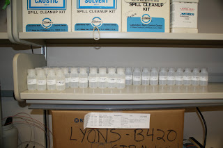
Once all the bottles are filled with salt water from the soil, they'll get analyzed by our chemist, Kathy Welch. What we'll learn from the samples is how much salt, of several different varieties is in the soil here. Understanding how salt has been sprinkled over the landscape is one of the keys for figuring out who lives where, and where the water will flow.
Saturday, November 6, 2010
The Big Picture
Sunday is lab tour day here in McMurdo. Folks from all over the station come in to the Crary lab to find out what the scientists are up to. As I was telling folks here about what it is that I do, I realized that I haven't really given a big picture explanation of what my research is all about. Most folks know that I disappear to Antarctica once a year or so--here's why!
As I mentioned earlier, I'm working with a project called the McMurdo Dry Valleys Long Term Ecological Research project (MCM-LTER). The LTER is actually part of a much larger network of scientists who are trying to understand how climate change affects ecosystems. You hear the word "ecosystem" a lot, but all it means is the relationships between living things (like trees or fish) and their physical habitat (soil, air, water, etc.) .LTER wants to know how those relationships are changing in a changing world.
The McMurdo LTER has it easy. We study one of the simplest ecosystems on the planet, the Dry Valleys I've been writing about. In Taylor Valley, sunlight, water, and soil are used by microbes and algae and moss to make food and energy (they're called "primary producers" and are the core of the food web). Some microbes eat algae or other microbes, which are all food for some tiny, microscopic invertebrates (things like rotifers and tardigrades) I think tardigrades look pretty alien:

The top predator in the Taylor Valley ecosystem is the fearsome nematode . This microscopic worm is only about 1 mm long (so about 100 of them could party on your pinky nail). And that's just about it.
So why is it important to understand the relationships between these simple living things and their environment, and how it is changing as the Antarctic climate changes? Because, like it or not, we live in an ecosystem of our own (they say up in Alaska, "Step out of the car, and into the food chain"). More broadly, we depend on clean air, soil, and water to grow crops. We depend on microbes in the soil to make it fertile, and on bees and other bugs to pollinate our plants. We depend on rivers and lakes for water, and on the very complex ecosystem of the ocean for food--and more importantly, for algae and plankton, that make most of the oxygen we breath every day through photosynthesis.
Learning about how a simple ecosystem is changing gives us a model for how more complicated ecosystems change as the air and soil warm. What will happen in Taylor Valley over the next few years to decades? Will the microbes that pry minerals from the soil suffer from warming dirt, cutting off the base of the food supply? Will the nematodes, feeling fast and feisty in the warm temperatures over-hunt and exhaust their food supply? Will the glaciers that ring the valley melt, flooding out organisms that cannot find dry habitats fast enough? These are the kinds of questions that the LTER is trying to answer (and many others, of course!). The answers to these questions will help us predict how the ecosystem that we inhabit will change as the physical world changes around us.
Time to head back to lab work. I'll be heading back out to the field tomorrow if the weather holds, and will write about what I've been up to on station.
As I mentioned earlier, I'm working with a project called the McMurdo Dry Valleys Long Term Ecological Research project (MCM-LTER). The LTER is actually part of a much larger network of scientists who are trying to understand how climate change affects ecosystems. You hear the word "ecosystem" a lot, but all it means is the relationships between living things (like trees or fish) and their physical habitat (soil, air, water, etc.) .LTER wants to know how those relationships are changing in a changing world.
The McMurdo LTER has it easy. We study one of the simplest ecosystems on the planet, the Dry Valleys I've been writing about. In Taylor Valley, sunlight, water, and soil are used by microbes and algae and moss to make food and energy (they're called "primary producers" and are the core of the food web). Some microbes eat algae or other microbes, which are all food for some tiny, microscopic invertebrates (things like rotifers and tardigrades) I think tardigrades look pretty alien:
The top predator in the Taylor Valley ecosystem is the fearsome nematode . This microscopic worm is only about 1 mm long (so about 100 of them could party on your pinky nail). And that's just about it.
So why is it important to understand the relationships between these simple living things and their environment, and how it is changing as the Antarctic climate changes? Because, like it or not, we live in an ecosystem of our own (they say up in Alaska, "Step out of the car, and into the food chain"). More broadly, we depend on clean air, soil, and water to grow crops. We depend on microbes in the soil to make it fertile, and on bees and other bugs to pollinate our plants. We depend on rivers and lakes for water, and on the very complex ecosystem of the ocean for food--and more importantly, for algae and plankton, that make most of the oxygen we breath every day through photosynthesis.
Learning about how a simple ecosystem is changing gives us a model for how more complicated ecosystems change as the air and soil warm. What will happen in Taylor Valley over the next few years to decades? Will the microbes that pry minerals from the soil suffer from warming dirt, cutting off the base of the food supply? Will the nematodes, feeling fast and feisty in the warm temperatures over-hunt and exhaust their food supply? Will the glaciers that ring the valley melt, flooding out organisms that cannot find dry habitats fast enough? These are the kinds of questions that the LTER is trying to answer (and many others, of course!). The answers to these questions will help us predict how the ecosystem that we inhabit will change as the physical world changes around us.
Time to head back to lab work. I'll be heading back out to the field tomorrow if the weather holds, and will write about what I've been up to on station.
Thursday, November 4, 2010
Back in Town
I'm back at McMurdo Station this weekend to process the samples I've been collecting over the past three weeks!
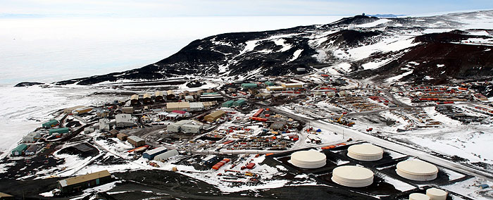
McMurdo Station is the main US base in Antarctica and is home (as of yesterday) to 1143 scientists and support staff (I guess I make it 1144 in total). The base is perched on the rocky shores of Ross Island, about a 45 minute helicopter flight from Lake Hoare in Taylor Valley.
In the above photo, you can see the big fuel tanks (to the right) that keep the lights on and the buildings warm. In the middle of the picture is the cargo yard, where several years of supplies are kept (in case weather turns bad, planes can't fly, and the resupply ship can't break through the ice). Over on the left side of the image is a gray building that's in three pieces connected by ramps. That's the Crary laboratory, which is the scientific heart of the station. It's where I'm writing from right now!
The bright white expanse to the far left is the frozen surface of the Ross Sea. All in all, it's a very tidy station, but after a few weeks out hiking and sampling, it seems like the big city!
In my next post, we'll take a closer look at what I'm doing in the lab, and just what it means to be washing dirt.
Subscribe to:
Posts (Atom)